Christopher J. Bessert: Portfolio Samples
Displayed here are a very small sampling of some of the maps and other projects I have completed in the past few years. Additional examples, hardcopy and/or digital versions are always available upon request.
Jump to:
Portfolio | General | Recreation | Utility | University | Transportation | Websites
| Recreational Maps | |
| Allegan Co. Road Atlas, Parcel Platbook & Recreation Guide | |
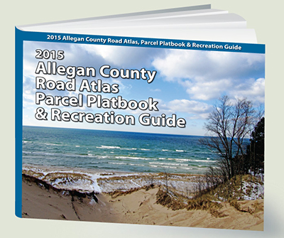 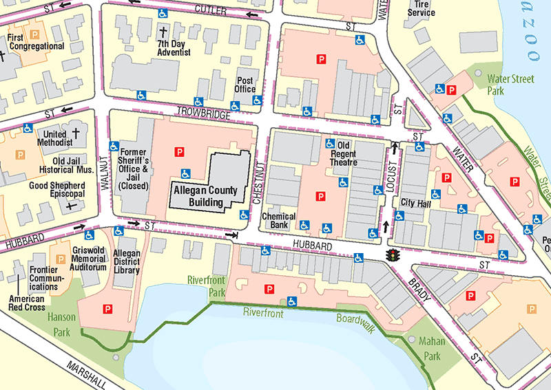 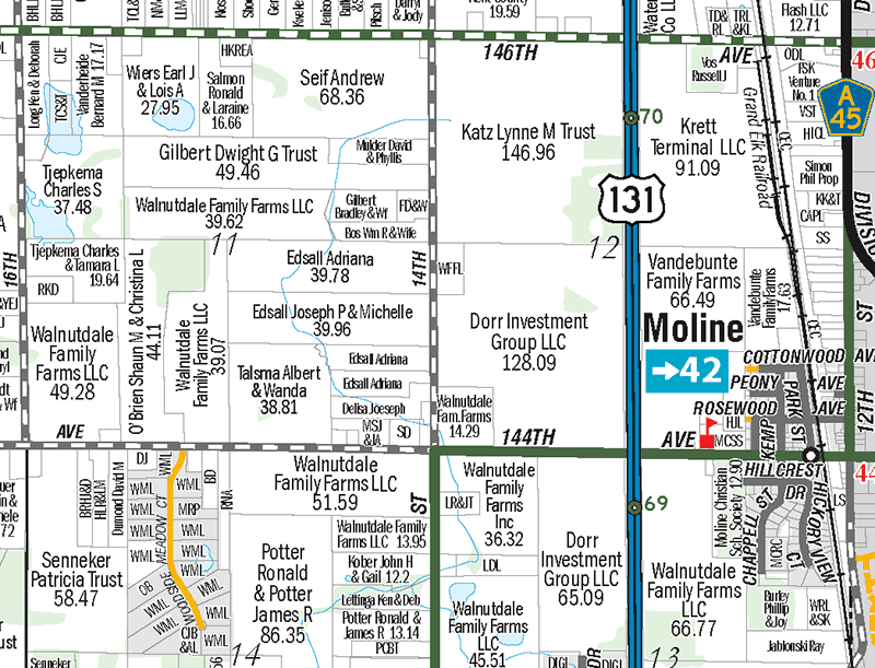 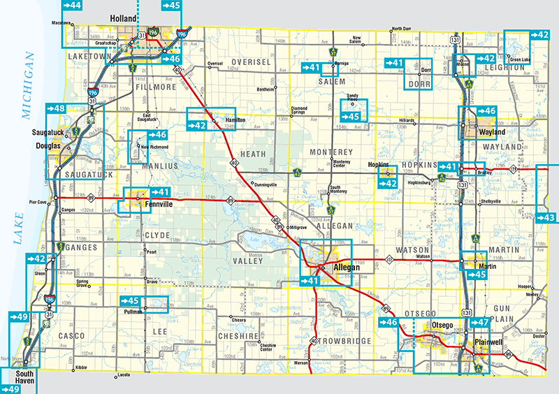 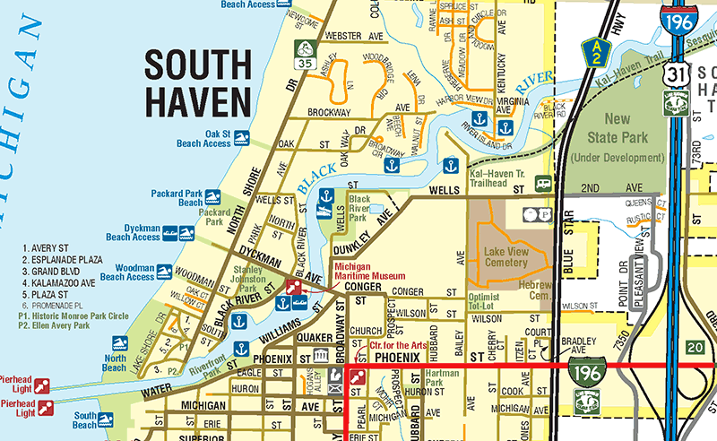 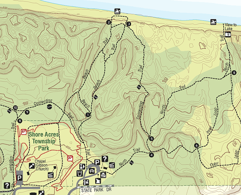 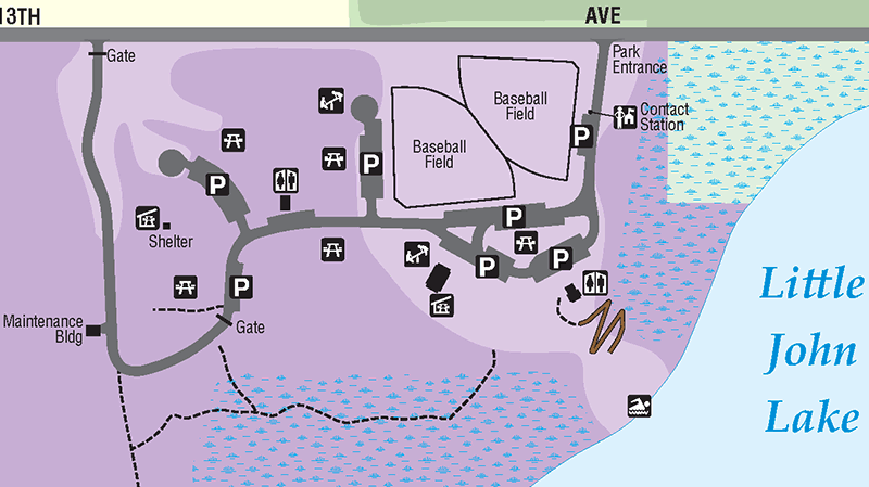 |
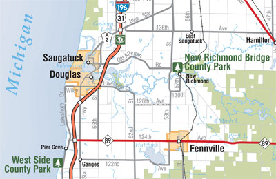
The 2015 edition of the Allegan County Road Atlas, Parcel Platbook & Recreation Guide was vastly expanded over previous editions. More than just a traditional county platbook, this publication greatly widens the user base to anyone living, working or nagivating in Allegan County. The atlas includes: • 4 pages of introductory and land description information, • a Regional Overview map, • 10 pages of sectional County Road maps, • 25 pages of Township Plat Maps, • 10 pages of City and Community Street Maps, • 8 pages of Recreational Maps, • 3 "special maps," • 12-page Parcel Owners Index. At top left is an image of the cover of the atlas. Excepts of just some of the many different types of maps in the atlas are shown at left. The second image shows a portion of the Downtown Allegan Map, indicating the locations of the various County facilities as well as on- and off-street parking and handicapped parking locations, other major landmarks, parks, trails and more. The third map at left is a small snippet of the Dorr Township plat map, where every parcel of 2½ acres or greater is indicated by the owners' name(s) and/or initials. Larger parcels include the calculated acreage of the parcel. The fourth map shows the various street-level maps included in the atlas. Every street map from the Official Allegan County Road Map is included (some with expanded coverage), along with maps of Green Lake, Sandy Pines & Lake Monterrey, Gun Lake Area, New Richmond, South Haven and the Lakeshore Region from South Haven to Glenn. The fifth map is an excerpt from the South Haven area street map as an example of the street-level mapping in the atlas. The sixth map at left comes from the Recreational section of the atlas and shows a portion of the Saguatuck Dunes State Park map, including elevation contours, wooded areas, hiking trails and all visitor amenities. The seventh and final map shows an excerpt from the Littlejohn Lake County Park map. All Allegan County parks and campgrounds are similarly mapped in the atlas—the first time all county parks have been mapped! The recreation section of the atlas also includes an Allegan State Game Area map, a map of the Equestrian Trail System and a comprehensive recreational facility index. |
| Bike Grand Rapids Map, 2011–2012 & 2017 | |
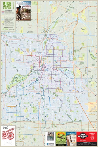 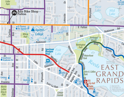 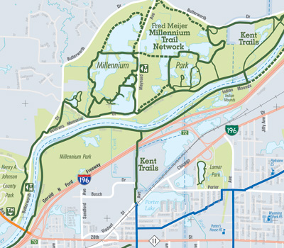 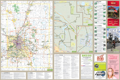 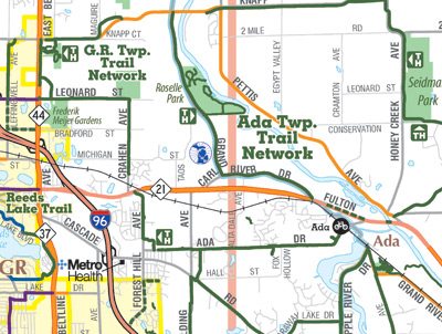 |
After having been published by the City of Grand Rapids Planning Department for eight years and four editions, the map was transitioned to the Greater Grand Rapids Bicycle Coalition—a not-for-profit bicycle advocacy group promoting the many benfits of bicycling in the region. While a select few graphic elements were continued from the previous editions, the 2011–2012 map was completely redrawn from the ground up, using the most recent and most accurate GIS data available, augmented by many hours of fieldwork and double- and triple-checking of the map information. The top map at left is an overview of the entire front of the map, showing the Greater Grand Rapids area from near Rockford on the north to Byron Center on the south and from Ottawa County on the west to Forest Hills on the east. The area of the map was increased from the old City-produced editions to take in many of the biking and recreational trails in the surrounding areas. The second and third maps from the top at left are two close-up views of the main map. Not only are all bicycle and shared-use pathways included, but all streets are shown (and labeled!) as are all parks, government buildings, schools, colleges, universities, libraries, and shopping centers. It's an excellent "general use" map of the Grand Rapids Metro area in addition to showing the bike routes and trails. The reverse of the map features three inset maps showing routes, trails and other details in the Ada/Cascade, Rockford and Cannon Township areas as well as a Kent County map giving bicyclists and recreational users an overview of the entire county at a glance. Also included are a listing of Trail Ettiquite, Bicycle Safety, and a listing of Trailheads with descriptions and GPS coordinates. As with most of my other maps, this map was completed largely as a one-person effort. A notable exception was the cover photo, taken by a local professional photographer. GGRBC members, local planning officials and other interested parties all assisted in the verification of the information shown on the map, however, and their assitance was invaluable. The map is available from many area bicycle shops, some governmental agencies, and at both area Schuler Books & Music locations. A digital version is available at the GGRBC website as well. The 2017 edition of the Bike Grand Rapids map is currently nearing completion and should be published soon. |
| Mackinac Island Tourism Bureau Map | |
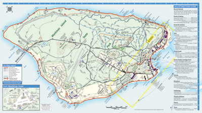 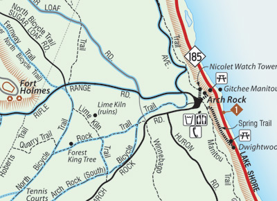 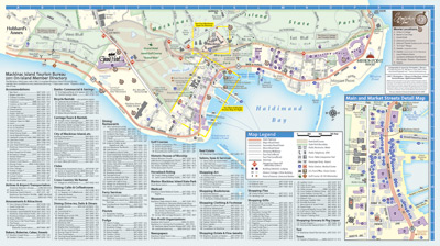 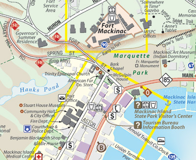 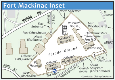 |
Having first made a fully-digital map of Mackinac Island in 1993, the current map is actually the third iteration. It was completely redrawn using more accurate GIS data in 2004 and then completely overhauled in 2011 when it was ported from Macromedia FreeHand to Adobe Illustrator. I have walked or bicycled almost every single road and trail on the Island, so this map is about as fully field-checked as any map could ever be. It has been described by others as "the most complete and accurate map of Mackinac Island... ever!" This map consists of several maps in one. First, a map of the full island showing all roads, trails, footprints of EVERY building on the Island, parks, golf courses (including greens), water features and public land ownership. This portion of the map also includes a comprehensive index of all Island visitor attractions and activities. The map includes every single road, street, trail, path, stairway and drive on the Island, classified by type and indicating surface (paved vs. gravel). Steep roads and trails are indicated where bicyclists, mountain bikers and hikers should exercise additional caution. The various bluffs which runs around the majority of the Island as well as the area around Fort Holmes are included to better show where steep climbs are encountered. A second map shows the southernmost portion of the island—the downtown area—in detail, as well as a complete index of all visitor and tourist-related businesses (lodging, dining, fudge shops, bicycle rentals, shopping, museums, etc.). An detailed inset map of the Main & Market Street Area shows the downtown core in even more detail. A third map shows Fort Mackinac, its buildings and walkways in extreme detail. |
| Greater Greening Lake, Bitely & Vicinity Map | |
|
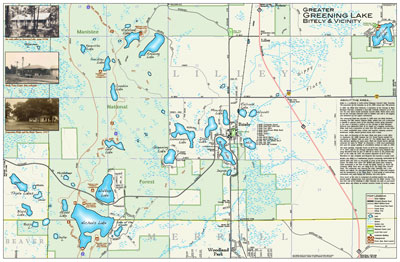
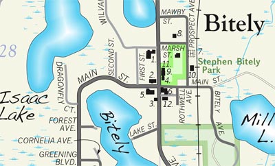
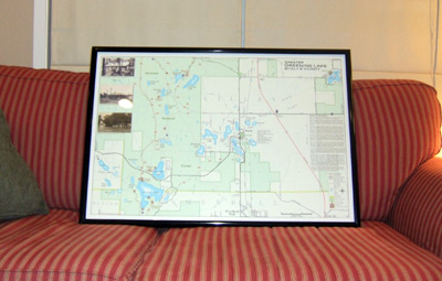
This map is a recreationally-focused map showing a portion of north-central Newaygo County, around the Bitely area. It highlights the area lakes, hiking trails, campgrounds and other recreational opportunities. It also includes several historic photos of the area along with a history of the region. Map measures 36" x 24" in size. A 400% close-up is included below the full map at left. A photograph of the finished and framed wallmap is included below left. A 34-page bound mapbook has also been created from this wallmap, including a Newaygo Co. map, lake depth maps of 11 area bodies of water, maps of several National Forest facilities and much more. |
| West Michigan Snowmobile Trail Map | |
|
A completely redrawn map for the 2009-2010 snowmobile season and updated for the 2012-2013 season, this map represents several months of work on behalf of both the West Michigan Snowmobile Council and myself. Likely one of the most detailed and accurate snowmobile maps available for the entire state, a wide variety of information important to the snowmobiler is featured on the map. The front of the map shows the local road system from Grand Rapids on the north to Kalamazoo on the south, Lake Michigan on the west to Hastings on the east. Overlaying this is the snowmobile trail system as well as staging areas, trail numbers and GPS coordinates at major junctions. All sponsoring businesses are indicated on the map in their proper location with both a number and a symbol corresponding to the service provided. The back of the map features the map cover, a listing of area snowmobile clubs, various rules and regulations for using the snowmobile trail system, and the listings for all of the businesses sponsoring the map. This map is available from many local businesses for a suggested donation of $2.00 per copy. |
| Allegan County Parks Locator Map | |
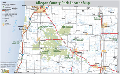  |
A basic, countywide map showing the locations of the various county parks in Allegan County, along with major roads, communities and other orienting landmarks. This is one map in a series produced for the Allegan County Department of Parks, Recreation, Tourism & Economic Development. Other maps include the Official Allegan County Visitor's Map, the Allegan County Recreation Map and the Allegan County Heritage Trail Map. The Parks map can be viewed online or downloaded from the County Parks website. |
| Cannon Trail Map | |
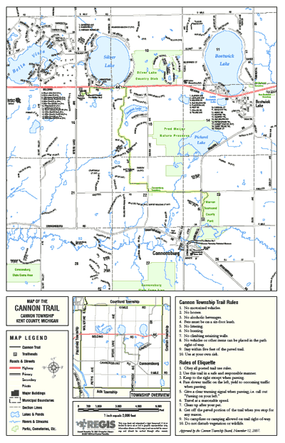 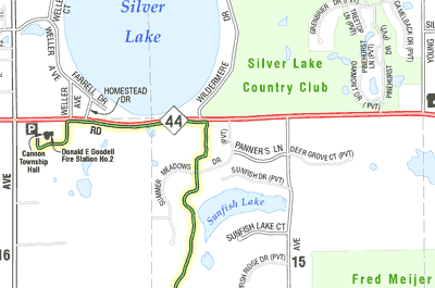 |
Cannon Township built a new multi-purpose trail in 2007 connecting their township office complex with the Warren Townsend County Park in Cannonsburg. A GPS unit was used in the field to map the location of the new trail, then within hours of this location data arriving in from the field, the map at left had been created. It was used in conjunction with the official opening of the trail in late 2007. It also includes a locator map showing the trail in relation to the rest of the township as well as a listing ot the Cannon Township Trail Rules and the Rules of Etiquette. Map measures 11" x 17" in size. A 400% close-up is included below the full map at left. |
|
|


Jump to: Résumé | Portfolio | Technology | Contact
This is a website created, authored and maintained by Christopher J. Bessert as a portal for information about him, his GIS, mapping, cartography, transportation-planning and webmastering projects, as well as a home for his resume, portfolio and a listing of many of the computer technologies and softeware he knows how to use.